Weekday Routes
All rides start and end at the Wheel & Sprocket Fox Point location.
All rides start and end at the Wheel & Sprocket Fox Point location.
|
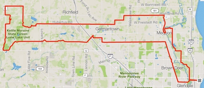
For 2023, we're back to our regular loop. Please obey all traffic signs and be extra careful crossing over I-43 on Highland Road and going through the Port Washington Road construction zone. Also, Lake Drive is in terrible shape, so treating the last mile or so as a sprint finish is dangerous. This is not a race. If you are riding with Group 1, 2, or 3, this is a drop ride. However, the group is asked to wait for riders that are caught at red lights or busy street crossings, like Good Hope Rd, Brown Deer Road, Mequon Road, etc. Group 4 and 5 riders should muster at these same points to allow any riders that have fallen back to rejoin the group. 26 Miles 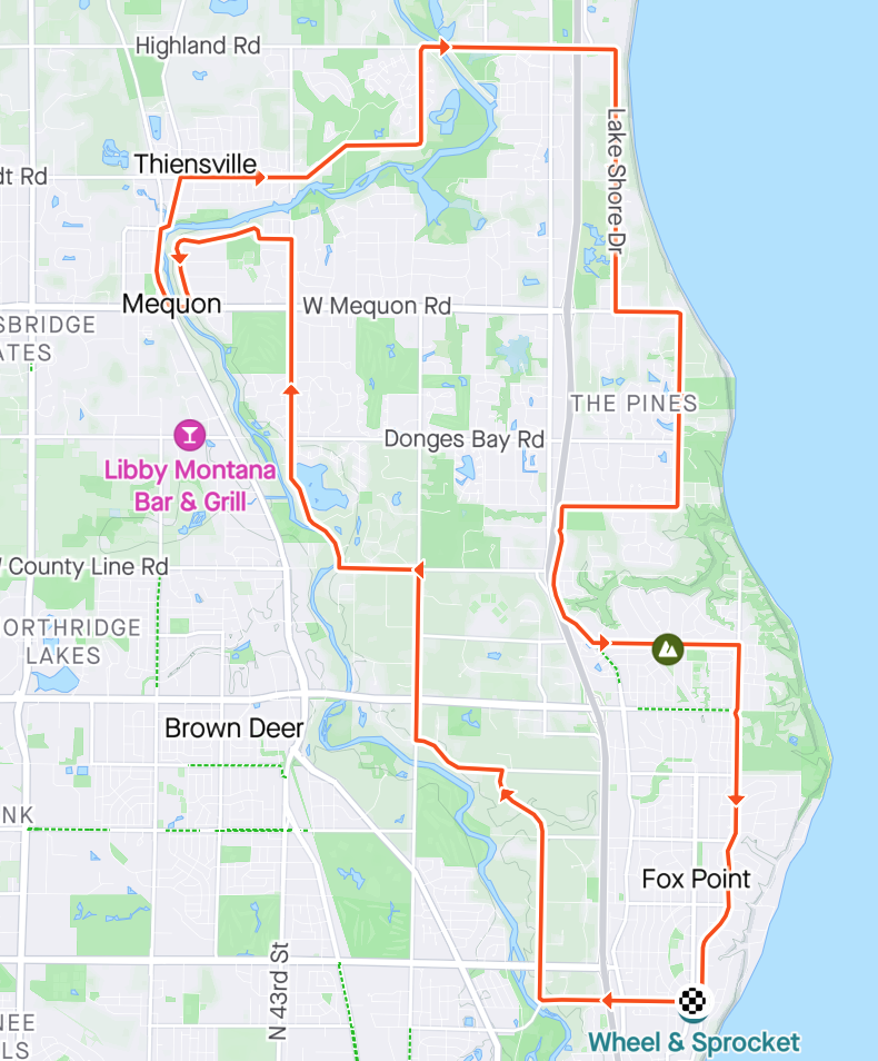
|
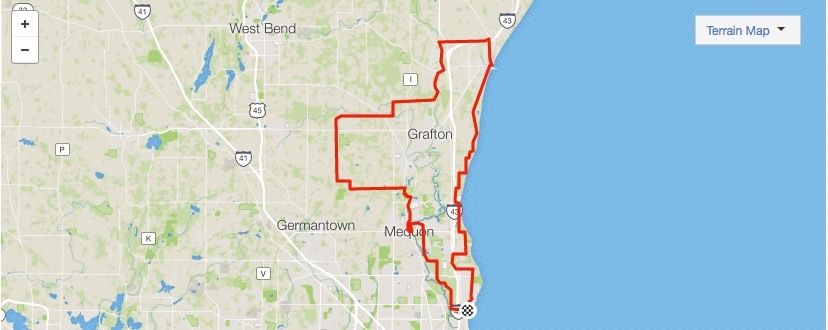
This Ride is being considered for 2023 - watch email communications to see if it returns Monday/Wednesday Night Group 4/5 Rides. Depending on the time of day and traffic, riders may choose to head north on Santa Monica and get on Lake Drive closer to the Schlitz Audubon Center to avoid Lake Drive traffic (as portrayed in the picture). 20 Miles 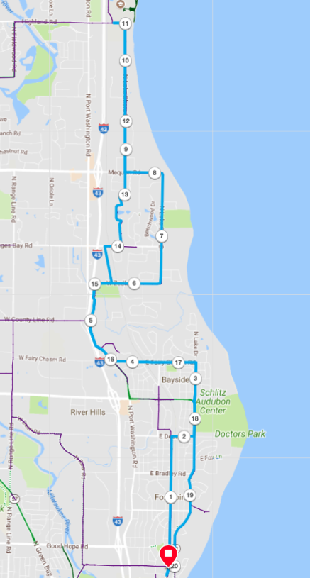
|
Saturday Morning Ride Options
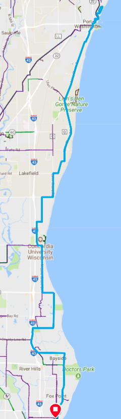
Port Washington Route
This is a standard route to Port Washington that includes a loop up and around Upper Lake Park. Many riders choose to not do this loop, rather just wait at a local coffee shop (there are many) for the rest of the group to conclude the loop and return to the coffee shop.
Below this route picture are three downloadable files; a cue sheet, a GPX file, and a TCX file. The GPX and TCX files can be loaded into devices that support that file type. Please consult your owners manual to see which file type, if any, your particular device supports. Devices that support one of these files will be able to project the route on the device, and in the case of GPX files, provide turn by turn directions.
Below this route picture are three downloadable files; a cue sheet, a GPX file, and a TCX file. The GPX and TCX files can be loaded into devices that support that file type. Please consult your owners manual to see which file type, if any, your particular device supports. Devices that support one of these files will be able to project the route on the device, and in the case of GPX files, provide turn by turn directions.
| ride_mke__w_s_to_port_and_back_|_route_cue_sheet.pdf |
| ride_mke__w_s_to_port_and_back.gpx |
| ride_mke__w_s_to_port_and_back.tcx |
Holy Hill Route
This is just one of many options for riding to/from Holy Hill.
Below this route picture are three downloadable files; a cue sheet, a GPX file, and a TCX file. The GPX and TCX files can be loaded into devices that support that file type. Please consult your owners manual to see which file type, if any, your particular device supports. Devices that support one of these files will be able to project the route on the device, and in the case of GPX files, provide turn by turn directions.
Below this route picture are three downloadable files; a cue sheet, a GPX file, and a TCX file. The GPX and TCX files can be loaded into devices that support that file type. Please consult your owners manual to see which file type, if any, your particular device supports. Devices that support one of these files will be able to project the route on the device, and in the case of GPX files, provide turn by turn directions.
| ride_mke__w_s_to_holy_hill_…_|_route_cue_sheet.pdf |
| ride_mke__w_s_to_holy_hill_and_back_-_just_one_option.gpx |
| ride_mke__w_s_to_holy_hill_and_back_-_just_one_option.tcx |
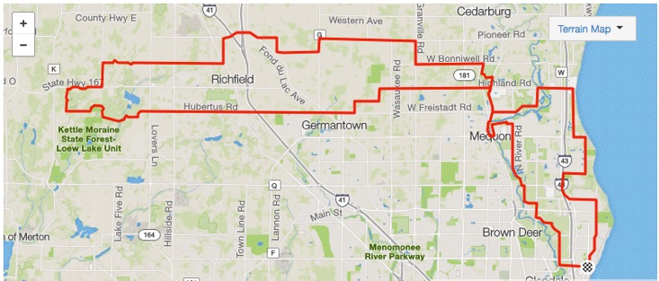
Holy Hill Route - coming in from the north and back via Monches
Here is another Holy Hill Route. This route takes you west on Freistadt/Hubertus as usual, but when you hit the intersection of St Augustine and Emerald, instead of going left on Emerald, you continue on St. Augustine across Holy Hill Road and go west on Pleasant Hill (for a slightly shorter option with a steep climb, go west on Shannon). Either way, you head south on Hwy K to Hwy 167 (Holy Hill Rd). A left and about a mile along you see the entrance to the Holy Hill National Shrine of Mary. Go right, and follow the road to the upper parking lot. Don't forget to climb all the way to the top and touch the brown door. Return home by going south on Hwy K to County Line Road, then east to Monches. You'll enjoy a beautiful ride along Monches/Scenic. Then a right on Willow and eventually head back to Milwaukee via Donges Bay Road to the bike path.
Below this route picture are three downloadable files; a cue sheet, a GPX file, and a TCX file. The GPX and TCX files can be loaded into devices that support that file type. Please consult your owners manual to see which file type, if any, your particular device supports. Devices that support one of these files will be able to project the route on the device, and in the case of GPX files, provide turn by turn directions.
Below this route picture are three downloadable files; a cue sheet, a GPX file, and a TCX file. The GPX and TCX files can be loaded into devices that support that file type. Please consult your owners manual to see which file type, if any, your particular device supports. Devices that support one of these files will be able to project the route on the device, and in the case of GPX files, provide turn by turn directions.
| |||
| holy_hill_-_coming_back_on_monches.tcx |
| holy_hill_-_coming_back_on_monches.pdf |
Covered Bridge Route
This is one option to ride across the Covered Bridge in Cedarburg
Below this route picture are three downloadable files; a cue sheet, a GPX file, and a TCX file. The GPX and TCX files can be loaded into devices that support that file type. Please consult your owners manual to see which file type, if any, your particular device supports. Devices that support one of these files will be able to project the route on the device, and in the case of GPX files, provide turn by turn directions.
Below this route picture are three downloadable files; a cue sheet, a GPX file, and a TCX file. The GPX and TCX files can be loaded into devices that support that file type. Please consult your owners manual to see which file type, if any, your particular device supports. Devices that support one of these files will be able to project the route on the device, and in the case of GPX files, provide turn by turn directions.
| covered_bridge_route_|_strava_route_cue_sheet.pdf |
| covered_bridge_route.gpx |
| covered_bridge_route.tcx |